

Information
Real Estate Drone Photography in Canton, Ohio
Integrity Aerial Imaging provides professional real estate drone photography and aerial property media for residential homes, commercial properties, land listings, farms, apartment buildings, development sites, and property managers throughout Canton, Ohio and Northeast Ohio.
Aerial photography helps show the full layout, size, location, roofline, driveway, land, landscaping, parking areas, surrounding roads, and overall condition of a property in a way that ground-level photos cannot. This gives buyers, sellers, agents, investors, and property owners a better visual understanding before they ever step on-site.
Whether you need drone photos for a home listing, commercial property sale, land marketing, rental property, farm, or development opportunity, Integrity Aerial Imaging can capture clean, professional aerial images that help your property stand out online.
Contact Integrity Aerial Imaging today for real estate drone photography in Canton, Ohio and surrounding Northeast Ohio areas.
Why Real Estate Drone Photography Matters
Real estate buyers often make their first decision online. Professional drone photography helps your listing stand out by showing the full property from a better perspective than standard ground-level photos alone.
Aerial photos can highlight the home, building, land, driveway, roofline, yard, parking areas, surrounding streets, nearby features, and overall property layout. This is especially useful for larger homes, commercial buildings, farms, vacant land, development sites, apartment communities, and properties with unique exterior features.
Drone photography gives buyers, agents, sellers, and investors a clearer understanding of the property before scheduling a showing. Better visuals can create more interest, improve listing quality, and help the property appear more professional in a competitive market.
Real Estate Properties We Photograph
Integrity Aerial Imaging provides real estate drone photography for a wide range of residential, commercial, and land-based properties throughout Canton and Northeast Ohio.
Our real estate drone photography services are ideal for:
Residential home listings
Luxury homes and large properties
Commercial buildings for sale or lease
Apartment buildings and rental properties
Farms and rural land
Vacant land and development sites
Industrial properties
Retail centers and office buildings
New construction homes
Investment properties
Large lots, acreage, and estates
Before-and-after property improvement photos
Aerial photography helps show the full value of a property by capturing the building, land, exterior features, access points, parking areas, surrounding roads, and overall layout. This gives potential buyers a clearer view and helps listings look more professional online.
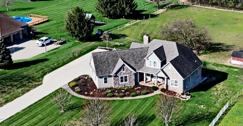
Residential Real Estate Drone Photography
Integrity Aerial Imaging provides professional drone photography for residential home listings throughout Canton, Ohio and Northeast Ohio.
Aerial photos can help showcase the home’s exterior, roofline, yard, driveway, landscaping, garage, outbuildings, surrounding neighborhood, and overall property layout. This is especially valuable for homes with acreage, large lots, pools, patios, wooded areas, detached garages, or unique exterior features.
For homeowners and real estate agents, drone photography adds a higher-quality look to the listing and helps potential buyers better understand the property before scheduling a showing.
Whether you are listing a standard residential home, luxury property, rural home, or large estate, professional aerial images can help your listing stand out and make a stronger first impression online.
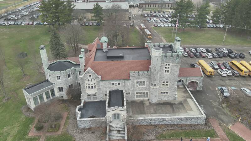
Commercial Real Estate & Land Listings
Integrity Aerial Imaging provides drone photography for commercial real estate, land listings, development sites, and investment properties throughout Canton and Northeast Ohio.
Aerial photography is especially valuable for commercial properties because it can show the full site layout, building size, parking areas, road access, loading areas, surrounding businesses, rooflines, property boundaries, and nearby traffic routes.
Our drone photography services are ideal for:
Commercial buildings for sale or lease
Retail centers and shopping plazas
Office buildings
Industrial properties
Warehouses
Apartment buildings
Vacant land
Development sites
Farms and acreage
Investment properties
Large parking areas and access roads
For commercial buyers, investors, tenants, and developers, clear aerial images help them understand the property faster. Drone photography gives your listing a more professional presentation and helps show the true scale and value of the property.
Farm, Land & Acreage Photography
Integrity Aerial Imaging provides drone photography for farms, vacant land, wooded acreage, rural properties, development lots, and large parcels throughout Canton, Stark County, and Northeast Ohio.
Aerial photography is one of the best ways to show the full size and layout of a property. Ground photos often cannot capture property lines, fields, wooded areas, ponds, barns, driveways, access roads, drainage areas, and surrounding land features clearly.
Our drone photography can help showcase:
Farms and agricultural land
Vacant lots and development sites
Wooded acreage
Large residential parcels
Rural homes with land
Barns and outbuildings
Ponds, fields, and pastures
Driveways and access roads
Surrounding roads and nearby features
Property improvement areas
For landowners, real estate agents, buyers, and developers, aerial photos provide a cleaner and more complete view of the property. This helps listings look more professional and gives potential buyers a better understanding of the land before they visit.
Commercial Real Estate & Land Listings
Integrity Aerial Imaging provides drone photography for commercial real estate, land listings, development sites, and investment properties throughout Canton and Northeast Ohio.
Aerial photography is especially valuable for commercial properties because it can show the full site layout, building size, parking areas, road access, loading areas, surrounding businesses, rooflines, property boundaries, and nearby traffic routes.
Our drone photography services are ideal for:
Commercial buildings for sale or lease
Retail centers and shopping plazas
Office buildings
Industrial properties
Warehouses
Apartment buildings
Vacant land
Development sites
Farms and acreage
Investment properties
Large parking areas and access roads
For commercial buyers, investors, tenants, and developers, clear aerial images help them understand the property faster. Drone photography gives your listing a more professional presentation and helps show the true scale and value of the property.
Drone Photos for Realtors, Sellers & Property Managers
Integrity Aerial Imaging helps real estate agents, homeowners, sellers, investors, and property managers create stronger property listings with clean professional drone photography.
For realtors, aerial photos can make listings look more polished and help attract more attention online. For sellers, drone images help show the full property value, including land, exterior features, parking, landscaping, and surrounding areas. For property managers and investors, aerial photos can help document buildings, rental properties, apartment communities, and commercial sites.
Our drone photography can be used for MLS listings, Zillow, Realtor.com, LoopNet, social media, websites, brochures, investor presentations, and property marketing packages.
Whether you are selling one home, marketing a commercial property, or managing multiple locations, Integrity Aerial Imaging can provide professional aerial images that help your property stand out.
What You Receive
Integrity Aerial Imaging provides clean, professional real estate drone media that can be used for listings, marketing, websites, social media, and property documentation.
Your real estate drone photography package may include:
High-resolution aerial photos
Overhead property views
Front, rear, and side aerial angles
Driveway and access point images
Land, yard, and acreage overview photos
Roofline and exterior building views
Parking area and commercial layout photos
Surrounding road and neighborhood context
Before-and-after property improvement images
Optional drone video or short promotional clips
Our goal is to provide useful, attractive images that help buyers, agents, sellers, and property owners clearly understand the property. Clean aerial visuals can make your listing look more professional and help your property stand out online.
Benefits of Real Estate Drone Photography
Professional real estate drone photography helps your property make a stronger first impression online and gives buyers a better view of what is being offered.
Key benefits include:
Better listing presentation
Stronger online attention
Clear view of the full property layout
Professional photos for MLS, Zillow, LoopNet, and social media
Better view of land, acreage, parking, and access points
Helps show property size and exterior features
Useful for homes, commercial buildings, farms, and land listings
Helps buyers understand the property before visiting
Adds value to real estate marketing materials
Makes listings look cleaner, sharper, and more professional
Whether you are selling a home, commercial building, farm, land parcel, or investment property, drone photography helps show the full picture and gives your listing a more professional edge.
Request Real Estate Drone Photography
If you need professional drone photos for a home, commercial building, farm, land listing, apartment property, development site, or investment property, Integrity Aerial Imaging can help.
We provide real estate drone photography throughout Canton, Ohio and Northeast Ohio for realtors, homeowners, sellers, property managers, investors, developers, and landowners.
Our aerial images help show the full property layout, exterior features, parking areas, land, access points, rooflines, surrounding roads, and overall property appearance from a professional overhead view.
Whether you need photos for MLS, Zillow, Realtor.com, LoopNet, social media, a website, or a property marketing package, we can provide clean aerial media that helps your listing stand out.
Contact Integrity Aerial Imaging today for real estate drone photography in Canton, Ohio and surrounding Northeast Ohio areas.
Integrity Aerial Imaging
Canton, Ohio
Real Estate Drone Photography | Aerial Property Media | Commercial Listings | Land Photography
Frequently Asked Questions
Do real estate listings benefit from drone photography?
Yes. Drone photography helps show the full property layout, land, roofline, driveway, parking areas, exterior features, and surrounding area. This gives buyers a better view than ground photos alone.
What types of real estate properties do you photograph?
Integrity Aerial Imaging photographs homes, commercial buildings, farms, land listings, apartment buildings, rental properties, development sites, industrial properties, and investment properties.
Can drone photos be used for MLS and Zillow listings?
Yes. Our aerial photos can be used for MLS listings, Zillow, Realtor.com, LoopNet, social media, websites, brochures, and other real estate marketing materials.
Do you offer drone video too?
Yes. We can provide aerial photos, drone video, short promotional clips, property overview footage, and before-and-after property documentation.
Are aerial photos helpful for land and acreage listings?
Yes. Drone photos are especially useful for farms, vacant land, wooded acreage, large lots, ponds, fields, access roads, and development sites because they show the full size and layout of the property.
Do you serve areas outside Canton, Ohio?
Yes. Integrity Aerial Imaging serves Canton, North Canton, Massillon, Akron, Cleveland, Independence, Alliance, Green, Jackson Township, Louisville, Canal Fulton, and surrounding Northeast Ohio areas.