

Drone Mapping, LiDAR & 3D Reality Capture
Transforming Aerial Data into Actionable Intelligence
Today's projects demand more than photographs—they require accurate, measurable data that supports planning, design, construction, asset management, and informed decision-making. Integrity Aerial Imaging provides advanced drone mapping, LiDAR scanning, and 3D reality capture services that deliver high-resolution aerial intelligence for commercial, industrial, municipal, engineering, and construction applications throughout Northeast Ohio.
Using advanced drone technology and professional data collection methods, our FAA Part 107 Certified Remote Pilots capture precise aerial imagery and digital models that help clients document existing conditions, monitor project progress, calculate volumes, inspect infrastructure, and create accurate digital representations of real-world environments.
Whether you're planning a construction project, managing infrastructure, documenting assets, monitoring site development, or creating digital twins of buildings and facilities, Integrity Aerial Imaging provides dependable aerial mapping solutions backed by professional service, advanced technology, and a commitment to accuracy.

Our Drone Mapping & LiDAR Services
Integrity Aerial Imaging provides comprehensive aerial mapping, LiDAR, and 3D reality capture services for commercial, industrial, municipal, engineering, agricultural, and construction projects. Every project is customized to meet your specific objectives while delivering accurate, high-quality data you can rely on.
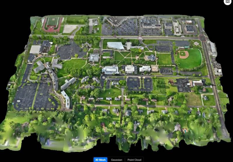
Orthomosaic Mapping
Generate high-resolution aerial maps that provide an accurate, measurable view of your property or project site. Orthomosaic maps are ideal for planning, documentation, inspections, and long-term asset management.
LiDAR Scanning
Capture highly accurate elevation and terrain data using advanced LiDAR technology. LiDAR is ideal for engineering, surveying support, utility corridors, construction planning, forestry, and infrastructure projects where precise measurements are essential.
3D Reality Capture
Create detailed three-dimensional digital models of buildings, facilities, construction sites, and infrastructure. These interactive models provide valuable visualization, documentation, and measurement capabilities for planning, inspections, and project management.
Construction Progress Monitoring
Document every phase of construction with scheduled aerial flights that provide visual updates, progress reports, and historical project records. These inspections help owners, contractors, and stakeholders monitor project development from start to finish.
Stockpile Volume Measurements
Accurately calculate stockpile volumes for aggregates, topsoil, sand, gravel, mulch, coal, and other materials. Drone-based volume measurements provide fast, reliable data for inventory management, production tracking, and operational planning.
Site Documentation
Capture existing site conditions before construction, renovations, or development begins. High-resolution aerial imagery provides valuable records for engineering, planning, permitting, insurance documentation, and future reference.
Infrastructure Inspections
Inspect bridges, towers, industrial facilities, utilities, pipelines, transportation corridors, and other critical infrastructure with detailed aerial imagery that improves safety and reduces inspection time.
Asset Management
Develop accurate aerial records of commercial properties, campuses, industrial facilities, and municipal assets to support maintenance planning, budgeting, inspections, and long-term facility management.
No matter the size or complexity of your project, Integrity Aerial Imaging delivers professional aerial mapping solutions designed to provide accurate data, meaningful insights, and exceptional value.
Why Drone Mapping & LiDAR?
Accurate data is the foundation of every successful project. Whether you're planning new construction, managing infrastructure, documenting existing conditions, or tracking project progress, drone mapping and LiDAR technology provide fast, reliable, and highly detailed information that supports better decision-making.
Traditional surveying and site documentation methods can be time-consuming, labor-intensive, and limited by terrain or accessibility. Advanced drone technology allows large areas to be documented quickly while capturing high-resolution imagery, elevation data, and three-dimensional models that provide a comprehensive view of your project.
At Integrity Aerial Imaging, we combine FAA Part 107 certified flight operations with advanced mapping technology to deliver professional aerial data tailored to your specific needs. Our services help engineers, architects, contractors, municipalities, developers, and property owners improve planning, monitor progress, manage assets, and reduce costly surprises throughout every phase of a project.
From construction sites and commercial developments to industrial facilities, transportation infrastructure, and agricultural operations, our mapping solutions provide accurate information that helps clients work smarter, plan more effectively, and make confident decisions backed by dependable aerial data.
Industries We Serve
Integrity Aerial Imaging proudly provides professional drone mapping, LiDAR, and 3D reality capture services to clients across a wide range of industries throughout Northeast Ohio. Our aerial data solutions support planning, engineering, construction, inspections, documentation, and long-term asset management.
Engineering & Surveying
Support engineering and surveying projects with accurate aerial mapping, topographic data, LiDAR scanning, and high-resolution site documentation that improves planning and project efficiency.
Construction & Development
Monitor construction progress, document existing conditions, create orthomosaic maps, and provide detailed aerial imagery throughout every phase of development.
Commercial Real Estate
Provide property owners, investors, and facility managers with detailed aerial documentation, 3D models, and property records for inspections, maintenance planning, and marketing.
Manufacturing & Industrial Facilities
Document large industrial sites, monitor facility expansions, inspect infrastructure, and maintain accurate digital records of valuable assets.
Municipalities & Government Agencies
Support public works departments, planning agencies, parks, utilities, transportation departments, and emergency management organizations with reliable aerial mapping and infrastructure documentation.
Agriculture
Assist farmers and agricultural operations with field mapping, drainage analysis, crop monitoring, and aerial data collection to improve operational efficiency and land management.
Mining & Aggregate Operations
Measure stockpile volumes, document excavation progress, monitor site conditions, and provide accurate inventory calculations using advanced aerial technology.
Utilities & Infrastructure
Inspect utility corridors, substations, pipelines, communication towers, bridges, and other critical infrastructure while reducing inspection time and improving safety.
Architecture & Design
Provide accurate aerial imagery and 3D models that support architectural planning, renovation projects, and site design.
Whether your project covers a single property or hundreds of acres, Integrity Aerial Imaging delivers dependable aerial intelligence that helps clients make informed decisions with confidence.
Why Choose Integrity Aerial Imaging?
Selecting the right aerial mapping partner is about more than owning advanced equipment—it's about working with a company that understands your project goals and delivers accurate, dependable results. At Integrity Aerial Imaging, we combine industry-leading drone technology with professional flight operations, detailed reporting, and exceptional customer service to provide aerial data you can trust.
Advanced Technology
We utilize professional drone platforms equipped with high-resolution cameras, RTK positioning, thermal imaging, and LiDAR capabilities to collect accurate, reliable aerial data for projects of every size.
FAA Part 107 Certified
Every mission is conducted by FAA Part 107 Certified Remote Pilots operating under federal regulations and industry best practices, ensuring safe and professional flight operations.
Accurate Data Collection
Our focus is delivering precise aerial imagery, mapping products, and digital models that support planning, engineering, construction, inspections, and long-term asset management.
Professional Reporting
We provide organized deliverables including aerial imagery, orthomosaic maps, 3D models, volume calculations, inspection documentation, and project reports tailored to your specific needs.
Customized Solutions
Every project is unique. We work closely with each client to develop a data collection plan that aligns with your objectives, schedule, and budget.
A Trusted Partner
Integrity Aerial Imaging is committed to building long-term relationships through professionalism, responsive communication, dependable service, and a dedication to delivering exceptional results on every project.
Our Mapping Process
Every successful mapping project begins with careful planning and ends with accurate, actionable data. At Integrity Aerial Imaging, we follow a proven workflow that ensures every client receives dependable results tailored to their project's specific requirements.
1. Project Consultation
We begin by discussing your project objectives, required deliverables, timeline, and any specific data collection requirements. This allows us to develop the most effective flight and mapping strategy for your site.
2. Mission Planning
Our team carefully plans each flight using advanced mapping software, airspace analysis, and site information to ensure complete coverage, accurate data collection, and safe flight operations.
3. Aerial Data Collection
Our FAA Part 107 Certified Remote Pilots collect high-resolution imagery, LiDAR data, thermal imagery (when required), and RTK positioning data using professional-grade drone systems designed for precision mapping.
4. Data Processing
Following the flight, all collected data is processed using industry-leading software to generate orthomosaic maps, 3D models, digital surface models, point clouds, stockpile calculations, and other project deliverables.
5. Quality Assurance
Every dataset is carefully reviewed to verify accuracy, completeness, and consistency before final deliverables are prepared for the client.
6. Final Deliverables
Clients receive professionally organized digital deliverables tailored to their project, including maps, models, reports, measurements, imagery, and supporting documentation that can be integrated into planning, engineering, construction, and asset management workflows.
Our structured approach ensures every project is completed with accuracy, professionalism, and a commitment to delivering reliable aerial intelligence that supports confident decision-making.
Frequently Asked Questions
What is drone mapping?
Drone mapping uses advanced unmanned aircraft systems to capture high-resolution aerial imagery and geospatial data that can be processed into orthomosaic maps, 3D models, elevation data, and other digital deliverables used for planning, engineering, construction, and asset management.
What is LiDAR?
LiDAR (Light Detection and Ranging) is a remote sensing technology that uses laser pulses to measure distances and create highly accurate three-dimensional models of terrain, structures, and vegetation.
What industries use drone mapping?
Our mapping services support construction companies, engineering firms, surveyors, municipalities, commercial property owners, developers, manufacturers, utility companies, agricultural operations, mining companies, and many other industries.
How accurate is drone mapping?
Accuracy depends on the project requirements and equipment used. Our professional drone systems utilize advanced positioning technology and carefully planned flight operations to deliver highly accurate mapping products suitable for a wide variety of commercial applications.
Can drone mapping replace traditional surveying?
Drone mapping is an excellent tool for documenting existing conditions, monitoring progress, collecting aerial data, and supporting planning efforts. Depending on the project, certain work may still require a licensed professional surveyor to perform or certify survey-related tasks.
How long does a mapping project take?
Project duration varies depending on the size and complexity of the site. Many projects can be flown in a single day, with processed deliverables provided after the data has been reviewed and processed.
What deliverables do I receive?
Depending on your project, deliverables may include orthomosaic maps, 3D models, point clouds, LiDAR datasets, digital elevation models, stockpile calculations, aerial imagery, inspection reports, and other customized project documentation.
Why choose Integrity Aerial Imaging?
We combine FAA Part 107 Certified flight operations, advanced drone technology, professional reporting, and a commitment to accuracy to provide dependable aerial mapping solutions for clients throughout Northeast Ohio.
We pride ourselves on our adaptability and commitment to excellence in every aspect of our service. Explore what we have to offer and how we can contribute to your success.
Start Your Mapping Project Today
Whether you're planning a construction project, documenting existing conditions, inspecting infrastructure, calculating stockpile volumes, or creating detailed 3D models, Integrity Aerial Imaging has the technology, experience, and expertise to deliver accurate aerial data you can trust.
Our FAA Part 107 Certified Remote Pilots utilize advanced drone mapping, LiDAR, RTK positioning, and reality capture technology to provide professional deliverables tailored to your project's unique requirements. From engineering and construction to commercial real estate, municipalities, industrial facilities, and agriculture, we help clients make informed decisions with reliable, high-quality aerial intelligence.
Every project begins with a complimentary consultation to discuss your objectives, project scope, timeline, and required deliverables. Our team will develop a customized aerial data collection plan designed to provide the information you need while maintaining the highest standards of safety, accuracy, and professionalism.
Request Your Free Project Consultation
Whether your project covers a single building or hundreds of acres, Integrity Aerial Imaging is ready to help.
Call: (330) 952-3171
Email: andy@integrityaerialimaging.com
Serving Northeast Ohio
Integrity Aerial Imaging LLC
Innovation Above. Integrity Below.
Professional Drone Mapping • LiDAR • 3D Reality Capture • Construction Documentation • Infrastructure Inspections • Aerial Intelligence